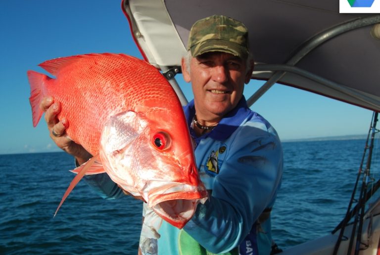
“Paddock Fish – Nannygai on Grass” – Bill Bowtell 2015
For the past 24 months I have been reporting from “On the Road”, or “Travelling Fisho”, as former Editor, Lee Brake, used to describe it.
The travel and chance to fish across this big country, was great experience and a real eye-opener. And I enjoyed most of my time on the road. The fishing was often a challenge for various and obvious reasons, but with the help of locals, a little ingenuity and a lot of observation, it all came together on most occasions.
But it was good to be home, especially when the Toyota dragged the Roadstar van, our home of two years, over Fred Lawn’s hill at the entrance to Yeppoon. Before us lay Keppel Bay, with its Keppel group of islands, resplendent in the soft rays of a mid-winter’s afternoon. The old familiarity was there.
Within a week things were almost back to normal. Within a fortnight, with fish in the freezer, things were back to normal. But there was some luck involved.
Before leaving on my extended trip I sold “S-Cape”, my 5.2mtr Seafarer Viking. The original plan was to be away several years and there seemed no sense in having the old workhorse sitting idle for any great length of time. So she went, but not without a lot of sadness. As she was going to a mate, Chris Campbell, I left almost all of my fishing marks in the waypoint list of the Garmin GPS. As I said – “almost all”. Some were copied into my fishing notebook then deleted.
Every angler I know has at least a few secrets up their sleeve. Be it a secret spot (very hard these days with the advent of GPS and social media), a secret bite time when a spot will really fire, a preferred lure type, bait type and the list goes on. The marks that I copied from the GPS were my “secret spots”. They were also very reliable and over the years had never failed to produce fish. However, in the cleanup upon returning home to Yeppoon after our trip, the notebook containing the marks was inadvertently thrown out!
In years gone by I would have sketched up a list of landmarks to cover these spots in my notebook. And if no landmarks were visible, copied any recordings, such as, bearings and distances from a reference point and depth of water, onto the relevant marine chart for safe-keeping. But with computers and GPS technology much of this type of referencing has gone by the wayside in preference to backing-up such data files on one’s home, or laptop, computer. Why my marks were never backed-up still haunts me, for, in this case, all but one of the seven deleted marks did not have any landmarks, just a references to one of the islands in the Keppel Group.
Wide of Keppel Bay, east to the Capricorn-Bunker Group of reefs and north to the Capricorn Channel, is a vast area of sand-drifts that are interspersed with low ridges of mud and shale and some rock outcropping. And within the surrounding confines of these mud/shale ridges, rock outcrops and shallow “sand-valleys” grow patches of soft ferns, whips and some isolates of coral and coral flower-pots. I refer to this vast area as “paddocks”, especially so in those areas where the soft ferns dominate.
These are the old former trawl gounds of the Capricorn Coast. Here, over many years of industry, tens of thousands of tonnes of mid-ocean kings, endeavourii and even banana prawns were harvested by more than sixty local and itinerant trawl boats operating out of Yeppoon’s Rosslyn Bay boat harbour, and other ports such as Mackay, Bundaberg and Tin Can Bay. And, when not chasing prawn, they would switch gear to delve the bottom to extract the succulent scallop. For which this area was well-noted.
It was a year round operation for many. And only dependent upon the weather and later, when stocks became noticeably less, seasonal and area closures. The bottom in these areas of “paddock” was dredged time and time again. The only things that remained near intact were the small, low, rock outcrops and patches of solid mud and shale ridges that could halt a trawler in its tracks. And, if the gear wasn’t slipped and the power taken off, then the boat would pull herself under the water and sink. There were several that went down over the years. The skippers referred to these obstacles (amongst other things!) as “hook-up” points.
But nature is a great healer, if given time and when conditions are favorable. Fortunately, the waters wide of Keppel Bay and north to the Capricorn Channel are arguable as pristine as any along the Queensland coast and, whilst the scallops and offshore prawns have not returned to anywhere near the former numbers, the bottom is slowly (after more than twenty-five years) repairing itself with new growth of soft ferns, whips and even some isolates of corals. The fish too have moved back into a regular pattern of visiting these very same areas. Find these patches and you will find the fish. However, success does depend on an understanding of how the fish behave in these, often broad, patches of sea-grasses and soft ferns.
Some years ago I had the opportunity to view underwater video that was taken as part of a fisheries research project conducted here in the waters along the Capricorn Coast. The device used was called a “BRUV” (Baited Remote Underwater Video) – self-explanatory. As an advisor to the project team I opted for some of this underwater videoing to be done in this former trawl area, specifically in two areas -: one, a known and recorded “hook-up” point. And the other, a point at the end of a mud/shale ridge where soft ferns were just beginning to regenerate. The results were informative and gave a good insight into both fish behavior and feeding pattern(s). The video(s) also gave clear indications of what species dominated what areas.
The hook-up points – generally low shelves of exposed rock with clearly defined ferns and whips – held schools of the small reef fishes, from what could be termed “aquarium fish” to the smaller Lutjanids – hussars, as an example. There were also coral trout (especially so if there were overhangs in the formation) red emperor (mainly juvenile) and of course gold spotted cod. Their behavior was predictable.
As the BRUV was lowered the smaller “aquarium fish” would move onto and pick the bait. This in turn would excite the smaller Lutjanids and they too would then attack the bait. This activity would entice out the trout. However, instead of attacking the bait supply, they would take up position just wide of the device. Moving only when a piece of bait was torn from the BRUV and drifted in their direction. All activity would then stop momentarily, and the area would clear. This always indicated that a large cod had moved into the area. It was ususal for the screen to “blot-out” as the big fish finned past the camera and moved in on the bait supply. The bait would be inspected, torn at a little, and then left for the other fish to pick up the pieces.
This was predictable activity near, or at either the top, or bottom, of the tide. At times of stronger tidal flow the results were far different. It was very noticeable that fish, that were NOT present at times of no run, suddenly appeared at the BRUV site, as the run in the tide increased. Larger red emperor, both large-mouth and small mouth nannygai, trevallies, sharks and even mackerel all appeared. Most likely drawn into the feeding site by the spread of bait pieces, but also, because it was a prime time for them to feed. This pattern of behavior was similar in those mud/shale sectors, with one major exception – location of the fish and to a lesser extent, fish species themselves.
At the mud/shale ridge sites there was a lot of evidence of regrowth of soft ferns, whips and some small isolates of growing corals, with a fair extension of this regrowth out onto the sand drifts bordering the low flat ridges of mud and shale. The BRUV, when used in these areas, showed timid, initial activity from more mature red emperor, nannygai, grass sweetlip and some small snappers as they moved from deep within the patches of weed and fern to inspect the device.
This timid activity was primarily at, or near the period of no-run in the tide. But, as was the case at the hook-up points, the visitation to the BRUV site was most active at the times when the run was steady to strong as evidenced by the wavering of the soft ferns and grasses in the area. And this activity came right down to numbers of fish that showed up at the site, how they schooled when in the area and their aggressive feeding habits. These were two very important factors for consideration when I first started exploring these areas back in the late eighties/early nineties. For they not only gave some indication of what type of bottom features to look for, but also a clear idea of how the fish should appear on the sounder at certain phases of the tide. To labour these two points.
This vast area of “paddock” is broad and generally flat with sections of rolling undulations. The growth that appears on the bottom in these areas is statically stable and mostly uniform in height, therefore the bottom appears, to the untrained eye, “flat and featureless”. But it is not. The mud and shale ridges attest to that fact. So do the sunken trawl boats! Find a ridge, sound it out and you will find fish. The important factor here however, is that the user needs to be able to interpret what he, or she, is looking at on the screen. It is not always that obvious.
These ridges may be broad – up to a kilometre wide and as much as six kilometres long. A slight dip, or rise (300-500mm) in these areas is worth noting and looking at, for in many cases this is how they appear as low, rolling, undulations with “prickles” of soft ferns on top. This is what the angler is looking for. Here a good quality sounder and a working knowledge of the use of sensitivity and gain is essential to determine the nature of the bottom over which you are sounding. It is important to be able to distinguish between mud/shale and sand and also how fish appear amongst (or just above) any fern/weed growth.
From the early tests done with the BRUV, images showed that the fish (especially nannygai and grassy sweetlip) at slack water, were down amongst the fern and weed where they basically appeared to be resting. They were scattered in ones and two’s. Then as the tide began to flow the soft ferns and grasses would wave and flatten somewhat and the fish would move and become active. Under these conditions the small prawn and crabs and even bottom shellfish on which the nannygai were feeding became exposed. To the observer – so did the nannygai! They began to school above the fern and move to feeding areas in greater numbers. This is an important point.
At times of slack water, you are actually looking for the fish amongst the soft ferns. On my sounder, a Furuno colour FCV-582L, fish, such as nannygai, emperor and sweetlip, appear as small blue flecks imbedded in the bottom, which is actually the soft fern as indicated by manipulating the gain and sensitivity controls. And then, when the run starts as the tides begin to ebb, or flow, the small blue flecks disappear and are replaced by a solid show of fish.
For the angler wishing to check out and find such spots, initially this means that he/she is looking for dips or rises in the bottom. A sea-bed that is solid with evidence of some form of growth of ferns, or isolates of coral. Flecks of fish life amongst the ferns at times of slack water THEN patches of fish over these solid areas when there is run in the tide. All of these points were put to the test on my last trip out.
It was a trip with Shane Beitzel. Our families go back a long way and we are firm mates. I had often spoken to Shane about this country and the fish it produces. There was always an open invitation for him on S-Cape, but it never quite eventuated. He was pretty upset when I told him that I had tossed out the co-ordinates of my marks. Over a rum, or two, we planned a foray into the paddocks, just to check it out and to see if we could find some of my old marks.
I had a reference point and obviously knew the general area in which to start looking. It was however, when I told Shane that if he went a certain distance from the reference point and pointed in a general direction towards the horizon, that he quizzed me.
“How do you remember that?” he asked.
“It came to me in a dream that I had last night”, was my reply.
His response cannot be printed in these pages. But it was true. I did dream it. And believe it, or not, but that distance, along with a bit of dead-reckoning put us within 600m of where I used to fish this “featureless bottom”. I told him that – “that’s the old surveyor in me, mate”. After an hour of searching we found fish, after they had risen from amongst the soft fern. They appeared as a solid ball over a solid bottom. We had our first mark.
When fishing these areas it is important to mark out the range of area over which the fish are feeding – “grazing” is a better term. When they rise off the bottom they school up and move about, but it is usually just over a given area depending on flow in the tide and probably, where there is the greatest concentration of food (or a particular source of food). In such cases it pays to cover the area whilst the fish are visible and mark the corners of their feeding range to account for any changes that may occur in tidal drift, or push of the wind.
With paddock fishing it has been found that to drift the area with a two-hook paternosta rig will get results. It also pays to set a mid-range floating bait as most often the bigger fish will move well off the bottom and really belt a drifting bait.
These big nannys will take a range of baits and it is worthwhile to check the stomach content of a couple of fish (or the first fish if the going is slow) to see what they are feeding on and try to match it.
This day Shane and I were fortunate. We had luck on our side to some extent. But it was nice to come home, find at least one of the old spots and know that the fish are still there. Some “secrets” don’t change! Now to find the other six spots!


